Like a bird soaring through the sky, drones have revolutionized the field of surveying. They offer a myriad of advantages and disadvantages that have reshaped the way we collect and analyze data.
From increased efficiency and cost-effectiveness to enhanced accuracy and safety measures, drones have undoubtedly made their mark. However, as with any new technology, there are challenges to overcome, such as data processing issues, privacy concerns, and regulatory restrictions.
So, buckle up and prepare to explore the advantages and disadvantages of drones in surveying, as we navigate through the advantages and disadvantages that lie ahead.
--Advertisement--
Advantages of Drones in Surveying
Drone surveys offer several advantages over traditional surveying methods, making them increasingly popular in the industry. Some of the key benefits of using drones in surveying include
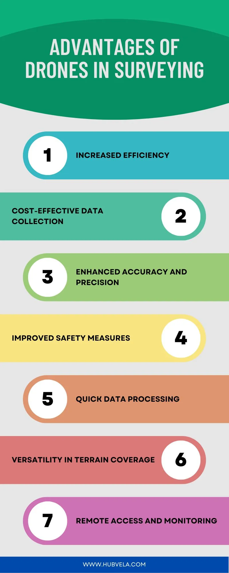
1. Increased Efficiency
Drones in surveying offer a significant advantage through increased efficiency, allowing for faster and more accurate data collection. With increased productivity, you can complete surveys in a fraction of the time it would take manually.
Drones provide real-time monitoring, enabling you to identify and address any issues immediately. They also ensure data accuracy, minimizing errors and reducing the need for rework.
Moreover, drones are cost-efficient, saving you both time and money in the surveying process.
2. Cost-Effective Data Collection
By utilizing drones in surveying, you can achieve cost-effective data collection, resulting in significant savings in both time and money.
Drones provide high data accuracy, allowing for precise measurements and detailed mapping. They also offer time efficiency, as they can cover large areas quickly and easily.
With real-time monitoring capabilities, drones provide reliable results that can be instantly analyzed and acted upon. Moreover, using drones eliminates the need for expensive equipment and manual labor, leading to substantial cost savings.
3. Enhanced Accuracy and Precision
Achieving enhanced accuracy and precision is one of the key advantages of incorporating drones into surveying.
Drones offer increased speed, which allows for quicker data collection and analysis. This, in turn, leads to enhanced productivity and improved data quality.
By reducing the need for manpower, drones streamline the surveying process and make it more efficient.
Moreover, the use of drones in surveying has expanded to various applications, further enhancing their versatility and effectiveness.
4. Improved Safety Measures
With the enhanced accuracy and precision achieved through the use of drones in surveying, another advantage is the improved safety measures they provide. Drones allow for improved data quality, as they can capture high-resolution images and videos from various angles. This reduces the need for surveyors to physically access hazardous or hard-to-reach areas.
Additionally, drones reduce labor requirements and increase surveying speed, allowing for faster data collection and analysis. The enhanced data visualization capabilities of drones also help in identifying potential errors, leading to reduced surveying errors overall.
5. Quick Data Processing
One major advantage of drones in surveying is their ability to process data quickly. Drones can provide real-time analysis, ensuring data accuracy and saving valuable time.
With the ability to process data rapidly, drones enable improved decision-making by providing up-to-date and reliable information. Additionally, drones offer data visualization capabilities, allowing surveyors to easily interpret and understand the collected data.
This quick data processing feature of drones enhances efficiency and productivity in surveying operations.
6. Versatility in Terrain Coverage
Drones in surveying offer a remarkable versatility in terrain coverage. With obstacle avoidance technology, they can navigate challenging landscapes, ensuring accurate data collection. Their high-resolution imaging capabilities provide detailed visuals for analysis. Real-time mapping allows for immediate assessment and decision-making.
Drones are also valuable in precision agriculture, enabling farmers to monitor crop health and optimize yields. Furthermore, they play a crucial role in environmental monitoring, aiding in the assessment and preservation of natural resources.
7. Remote Access and Monitoring
By utilizing drones in surveying, you gain the advantage of remote access and monitoring capabilities. Drones allow for real-time monitoring of survey sites, providing immediate access to data and allowing for quick decision-making. This increases data collection efficiency and enhances project supervision.
Additionally, drones help minimize the environmental impact of surveying by reducing the need for ground vehicles and personnel on-site.
Disadvantages of Drones in Surveying
Drone surveying has become a popular method for conducting land surveys in various industries. It involves using unmanned aerial vehicles (UAVs) equipped with cameras and sensors to collect data.
While drone surveying offers numerous advantages, such as faster data collection, increased accuracy, and improved safety, there are also some downsides to consider.
We will discuss the disadvantages of drones in surveying, including limited flight time, weather restrictions, and data processing challenges.

1. Safety Concerns
One major safety concern associated with using drones for surveying is the potential for collisions with other objects or people. To address this concern, drone regulations have been implemented, along with privacy concerns and safety guidelines.
Accident prevention and risk management are crucial aspects in ensuring the safe operation of drones. By adhering to these guidelines and regulations, the risk of accidents and collisions can be minimized, making drone surveying a safer and more reliable method for data collection.
2. Limited Flight Time
Using drones for surveying has the disadvantage of limited flight time. Battery limitations and power constraints restrict the duration of a drone’s flight. This can be a challenge when conducting large-scale surveys or covering vast areas.
Energy management becomes crucial to ensure that the drone doesn’t run out of power mid-flight. Surveyors need to carefully plan their missions and consider the flight time restrictions imposed by the drone’s batteries to maximize efficiency and productivity.
3. Weather Dependency
Weather dependency poses a significant disadvantage for drones used in surveying due to the impact of external environmental conditions. Drones are highly sensitive to weather conditions such as strong winds, heavy rain, and extreme temperatures. These challenges can limit the usability and reliability of drones in surveying operations.
To overcome these limitations, alternatives such as using manned aircraft or ground-based surveying techniques are often employed. However, advancements in drone technology, including improved weather resistance and predictive algorithms, are being pursued to mitigate the impacts of weather dependency.
4. Costly Equipment Maintenance
Maintaining drones used in surveying can be costly due to the need for regular equipment upkeep and repairs. The equipment lifespan of drones can be affected by various factors, such as weather conditions and frequency of use. This means that drones may require more frequent maintenance and repairs, leading to increased maintenance costs.
Additionally, drone maintenance often requires technical expertise and equipment calibration, which can further add to the expenses. Moreover, training requirements for drone maintenance personnel can also contribute to the overall costs.
5. Data Processing Challenges
After addressing the costly equipment maintenance associated with drones used in surveying, it’s important to consider the data processing challenges that can arise during the surveying process.
One of the main challenges is ensuring data accuracy. Drones can capture vast amounts of data, but it’s crucial to process and interpret this data correctly.
Additionally, integrating data from different sources can be complex and time-consuming. Storing and managing large amounts of surveying data also poses challenges, as does ensuring data security to protect sensitive information.
6. Privacy Issues
Privacy concerns are a significant disadvantage of using drones in surveying.
The use of drones raises legal implications regarding the collection and use of personal data. Data security becomes a crucial issue, with the potential for unauthorized access or breaches.
Public perception of drones in terms of invasion of privacy can also affect surveying projects. The ethical considerations surrounding the use of drones in collecting sensitive information need to be addressed to ensure privacy rights are upheld.
7. Regulatory Restrictions
Regulatory restrictions pose significant challenges for your use of drones in surveying projects. To comply with regulations, you must navigate airspace restrictions and meet licensing requirements.
Additionally, privacy concerns and potential legal implications can arise when using drones for surveying. It’s crucial to ensure regulatory compliance to avoid penalties and legal issues.
These restrictions may limit the flexibility and efficiency of your surveying operations, making it essential to carefully consider the regulatory landscape before utilizing drones.
Conclusion on Advantages and Disadvantages of Drones in Surveying
In conclusion, drones offer numerous advantages in the field of surveying. They provide increased efficiency, cost-effective data collection, enhanced accuracy, and improved safety measures.
Drones also offer quick data processing, versatility in terrain coverage, and remote access and monitoring capabilities.
However, there are certain disadvantages to consider, such as safety concerns, limited flight time, weather dependency, costly equipment maintenance, data processing challenges, privacy issues, and regulatory restrictions.
Despite these drawbacks, the benefits of using drones in surveying outweigh the limitations, making them a valuable tool for professionals in the industry.

Ahmad Ali (Author)
Ahmad Ali has been a technology enthusiast and writer for the past 5 years having vast knowledge of technology.

Rehmat Ullah (Content Reviewer)
Rehmat Ullah is a software engineer and CEO of Softhat IT Solutions. He is an expert technologist, entrepreneur, and educationist.